visual resource management visual simulation training design
Home
Company Services
Projects
Personnel
FAQ's
Contact Us
Site Map

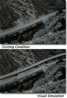
U.S. Highway 189 connects Provo and Heber City, Utah through scenic Provo Canyon. During conceptual design several alternatives were considered, including elevated structures and tunnels. Ellsworth and Associates, landscape architects, inc. developed a series of computer visual simulations of these alternatives.

The elevated structure concept is seen in two visual simulations, one from the fisherman's view on grade. This view was considered very important due to the heavy recreational fishing use of the Provo River. The second visual simulation illustrates the relationship of the elevated and cantilevered structures to the steep sides of the canyon and the Provo River.
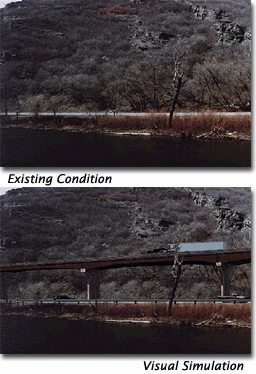
There is one photograph here of the existing view from standing in the Provo River, and a second image of the visual simulation of the proposed elevated highway structure from this viewpoint.There is one photograph here of the existing view from standing above the Provo River on the mountain side, and a second image of the visual simulation of the proposed elevated highway structure from this viewpoint.

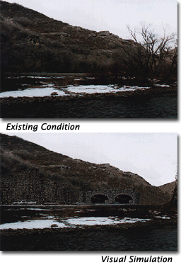
The proposed tunnels were simulated from on grade and from across the Provo River (the recreationist's view). These tunnels would reduce the amount of earthwork cut and fill required, thereby limiting the visual impact on the scenic canyon and the river.
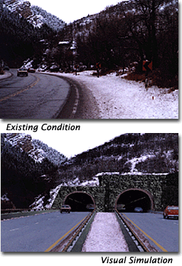
There is one photograph here of the existing view from driving on the proposed highway looking down the canyon, and a second image of the visual simulation of the proposed tunnel portals from this viewpoint.There is one photograph here of the existing view from standing in the Provo River, and a second image of the visual simulation of the proposed proposed tunnel portals from this viewpoint.

EALA's work added value to the Provo Canyon Highway project in the following ways...

  • Saved costs to the state highway department, designers, and contractors by decreasing time needed for consideration of alternative designs
  • Facilitated agency discussion of alternative highway alignments
  • Facilitated preliminary design review of selected alternative alignments
  • Effectively showed how the steep slopes, riparian areas, and sensitive canyon environment would be minimally impacted
  • Illustrated the relationship of the proposed highway improvements to the existing highway
  • Convincingly used to great advantage in public hearings to explain the project


Top of Page

Home | Services | Projects | J. Ellsworth | FAQ's | Contact | Site Map


All text and images copyright © 2005 Ellsworth and Associates, landscape architects, inc. All rights reserved.