
|
This project is located on the Pinedale Anticline in western Wyoming. The project proponent was seeking a permit from BLM for the development of several oil and gas drilling sites. A full Environmental Impact Statement (EIS) was required, including a complete analysis of the impacts on visual resources using the BLM’s Visual Resource Management (VRM) system. Ellsworth and Associates, landscape architects, inc. was contracted by the proponent to conduct the visual analysis which included extensive use of GIS visibility mapping, computer visual simulations, contrast rating, and recommendations for visual mitigation strategies. The visibility mapping was accomplished
by EALA using 10-meter Digital Elevation Model (DEM) data referenced to
several Key Observation Points (KOP’s).
Global Positioning System (GPS) technology was utilized to determine the
precise location of the KOP’s. A typical driver’s observation
height of 3.75 feet was established. ArcInfo GIS software was then used to
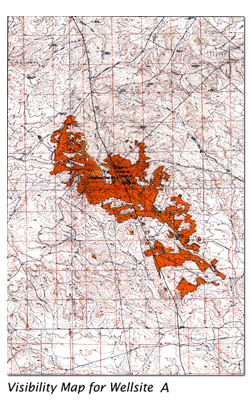
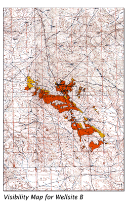
generate visibility maps for nine drilling sites.
On these maps, red represents areas of the landscape from which an individual proposed oil and gas drilling site would be visible if 12-foot tall tanks were used. Yellow represents additional areas from which the drilling site would be visible if 20-foot tall tanks were used. Numerous visibility maps were developed for each of the various proposed drilling sites. Computer Visual Simulations were
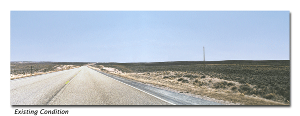
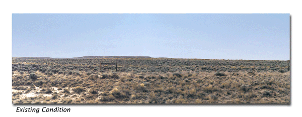
required for the contrast rating analysis of three of the drilling sites
that were in close proximity to the existing
US highway. Eight KOP’s were established for which 12 computer visual
simulations were developed, showing the change in visual condition 25 years
into the future when revegetation would be complete.
Various development options were simulated to show how a change in location of the drilling pad and facilities would affect the visual experience of the passing motorist. Careful attention was paid to accurately simulating the subtle changes in the appearance of the landforms required to construct the access road and level drilling pad with successful revegetation 25 years into the future.
EALA's work added value to the Pinedale Anticline Oil and Gas project in the following ways...
|
|||||||||||||||||

Home | Services | Projects | J. Ellsworth | FAQ's | Contact | Site Map
![]()
All text and images copyright © 2005 Ellsworth and Associates, landscape architects,
inc. All rights reserved.